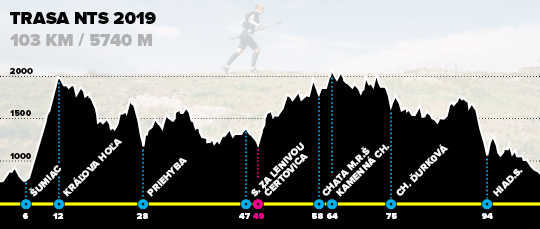
The NTS race course goes through the whole main Low Tatras ridge. Starting point is village Telgárt, destination point is Donovaly mountain resort. The NTS course follows the blue marked cyclo-trail from Telgárt to Šumiac, the next passage is the blue-marked bike trail from Šumiac to Kráľova hoľa and further the red-marked hiking trail to Donovaly (with branching-off to Ďurková chalet following the green-marked hiking trail).
Nízkotatranská stíhačka 2024 course parameters:
- Total distance: 98.5 km
- Total altitude gain: 5640 m
- Total altitude loss: 5540 m

GPX track for NTS103 – zip file, to download, right-click and choose “Download linked file”
GPX NTS100 – gpx file, click and in the upper right corner press “Download”
Online map – click to open interactive online hiking map
Detailed itinerary – PDF with detailed itinerary
Checkpoints for NTS 2019 course:
- KS1: Šumiac, square – 4,9 km / 180 m / no time limit
- KS2: Kráľova hoľa, summit – 10,4 km / 1220 m / limit 9:00 am
- KS3: Priehyba saddle – 26,1 km / 1 780 m / limit 10:00 am
- KS4: Ramža – 40 km / no time limit
- KS5: Saddle za Lenivou – 44,7 km / 2 790 m / no time limit
- KS6: Čertovica saddle – 46,6 km / 2 810 m / limit 5:00 pm
- KS7: Chata M.R.Štefánika (challet) – 54,6 km / 3 550 m / limit 7:30 pm
- KS8: Kamenná chata pod Chopkom (challet) – 60 km / 4 000 m / limit 9:30 pm
- KS9: Útulňa pod Chabencom (Ďurková challet) – 71,1 km / 4 470 m / limit 1.00 am
- KS10: Hiadeľské saddle, shelter – 89,3 km / 5 240 m / limit 5.30 am
- Finish: Donovaly, recreation area – 98,5 km / 5 640 m / limit 8.00 am
Elimination
Due to the rules of the National park, only 100 participants are allowed to continue beyond Čertovica. Because of this, participants who will arrive to KS5 Čertovica at position 101 and lower will not be allowed to continue. There will be a transport bus from KS Čertovica to the finish provided by the organizer.
Type of terrain: Foothpaths (90%), tracks/drivable tracks (4%) and roads (6% – the longest 2 km passage in Donovaly before finish).
